Meeting d'Aviation de Nice
Nice, France, April 15th - 24th, 1910
Nice, France, April 15th - 24th, 1910
The Nice/Californie airfield

The airfield continued to be active and under constant development and the present "Nice Côte d'Azur" airport is much, much bigger. The coastline has been moved far out into the sea, particularly during the 1970s when the field was expanded and a second landing strip was added. Around three square kilometres of land has been reclaimed from the sea. This was not without problems: In October 1979 a huge submarine landslide during construction work south of the airport caused a tsunami which first made the sea level locally drop by more than two metres and then led to waves up to seven metres high, resulting in the death of ten people and great damages along the coastline. The landslide cut submarine telephone cables 110 kilometres off the coast and it is calculated that around 150 million cubic metres of sediments shifted.

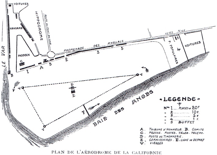
The plan of the airfield from one of the meeting programs. North is
at twelve o'clock.

A map showing the courses for the "cruise" races and the
flight by Van den Born on 24 April. (1)

A superb panorama looking across the Baie des Anges, with the gun
butt with the time-keepers' hut and the signal mast in the
centre. Chávez in the #8 Farman is heading for the first pylon. On
the ground: Efimoff's #11 Farman in the centre, Van den
Born's Farman #5 to the left and Olieslagers' Blériot to the
right. (2)

A view of the decorations around the grandstand pavillion - but the air traffic congestion appears a bit exaggerated... (3)
Too see more details, open the map in Google Maps by clicking the
"full screen" symbol at the top right of the menu bar!
 Back to the top of the
page
