Grosses Internationales Flugmeeting
Mülhausen im Elsass, Germany, July 2nd - 4th, 1910
Mülhausen im Elsass, Germany, July 2nd - 4th, 1910
The Mülhausen/Habsheim airfield


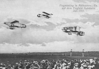
A postcard view of the airfield. The airplanes are
retouched in - the nearest Voisin is Étienne
Bunau-Varilla's #27 from the 1909 Reims
meeting... (1)
The airfield continued to be used by Aviatik until the start of World War One, hosting a couple of more meetings. After the start of the war the Aviatik factory and all its planes were immediately moved out of Alsace and the proximity of the French border, first to Freiburg on the other side of the Rhine and then to Leipzig in eastern Germany. The military took over the field, which was used as a forward landing field rather than a permanent base. It hosted several different units, among them a couple of famous Jagdstaffeln.
After the war, the French armed forces took over the field, using the northern part as army practice grounds and the southern part as airfield. The air force squadrons moved out already during 1919, however, with the airfield becoming an emergency landing field. It wasn't until 1929 that organized flying returned, with the formation of the club "L'Hélice", which then turned into the "Aéro-Club du Haut-Rhin", which was very active during the 1930s.
During World War Two the airfield again became German. They built two permanent gravel strips, but since the airfield was far from the western front and there were other more important airfields in the area it wasn't used by any operational units. It was also used as a prisoner-of-war camp for Polish prisoners, and part of the field was cultivated.
After the war the "Aéro-Club du Haut-Rhin" was revived, relaunching its general aviation and gliding activities. In 1962 the airfield became a base for the "Aviation Légère de l'Armée de Terre", the light aircraft and helicopter reconnaissance and support services of the French Army. The army base closed in 1977, and the airfield became again entirely civilian. It is still the home of several active flying clubs. In 1981 the main 02/20 runway was covered with tarmac.
The airfield is perhaps best known for the dramatic and controversial accident in 1988, when the brand new third production Airbus A320 crashed into the forest immediately north of the field when it hit the trees at the edge of the airfield after an extremely low and slow flypast. Three of the 130 passengers were killed and 34 injured.

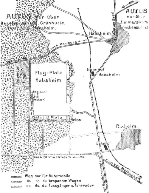
A map of the airfield from the program of the meeting. It is inverted, north is at seven o'clock.
Too see more details, open the map in Google Maps by
clicking the "full screen" symbol at the top
right of the menu bar!
 Back to the top of the page
